- Willem Badenhorst

- Sep 16, 2024
- 2 min read
Updated: Sep 17, 2024
Community forms and patterns in the South African built environment

MandalaGIS has been actively involved in a wide range of urban and rural development projects over the years. Currently, they are contributing to an open space management framework for South Africa, where they have identified the need for a comprehensive visual and descriptive tool. This tool is designed to foster collaboration between town and regional planners and environmentalists, enabling them to better understand and address the unique challenges of South Africa's built environment.
An urban to rural transect is a conceptual tool used in geography and urban planning to describe and analyse the changes in land use, population density, infrastructure, and environmental features as one moves from the centre of a city (urban core) to the countryside (rural areas). This transect helps illustrate the gradient or continuum of human environments, from densely built urban spaces to sparsely populated rural areas. The transect can be divided into distinct zones or regions, each representing a different type of human settlement.
Purpose and Importance
The urban to rural transect is used to analyse how different forms of land use, transportation, housing, and infrastructure evolve along this spectrum. It also helps urban planners understand how these areas interact, predict the impact of urban sprawl, and design sustainable development that balances urbanization with preserving rural areas.
In planning, the transect can help regulate development by specifying what types of buildings and land uses are appropriate for each zone, thus fostering more organized and efficient growth that meets the needs of both urban and rural populations.
By encouraging a shared language between these disciplines, the initiative aims to bring them closer together in their approach to sustainable development.
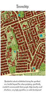
This Urban to Rural Transect diagram seeks to address precisely that—highlighting the structural differences within the South African context. Many academic articles on transects often fail to reflect local dynamics, offering only a generic view. Our hope is that this diagram will serve as a valuable tool for fostering communication between various disciplines. While it’s designed primarily for use by planners, the poster also has educational value and can be utilized in schools. Feel free to download and print the poster—it could make a great addition to your office or classroom!


Download the poster from here: https://www.mandalagis.com/artwork


