Is Aerial/Satelite Imagery better?

Aerial photos only gives a top angle


With ScoutMaster you can see activity and signage


With ScoutMaster you can see the signage, only then can you create this:


But what about Google Street View?
Street View does not always cover entire study areas
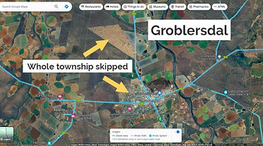
Only main routes done in smaller towns
_edited_edited.jpg)
Informal and poor areas gets "red-lined"

Main routes and areas with economic activity gets preference

Remote areas are not priority
StreetView is most of the time outdated!

Less affluent areas do not get regular updates. Sometimes > 7 years old.

Side Streets (even in popular areas like Loftus Versfeld) not regularly updated
Alice Lane in Sandton
Date analysed: Feb 2024
Latest Street View image: Mar 2020
Image intervals: 2015 - 2017 - 2020

Hans Strydom Ave in Cape Town CBD
Date analysed: Feb 2024
Latest Street View image: July 2022
Image intervals: 2009 - 2010 - 2013 - 2015 - 2017 - 2022

East London CBD
Date analysed: Feb 2024
Latest Street View image: Aug 2022
Image intervals: 2009 - 2014 - 2022

Selosesha Unit 1 - Thaba Nchu - Free State
Date analysed: Feb 2024
Latest Street View image: Oct 2010
Image intervals: April and Oct 2010
